


Digital Heritage
Chinese Scientists Discover Overseas Archaeological Sites for the First Time along the Silk Road by Remote Sensing
Date:2019-04-04
Background: A space archaeological research team, which was led by Prof. Wang Xinyuan, Deputy Director of the International Centre on Space Technologies for Natural and Cultural Heritage (HIST) under the auspices of UNESCO, in collaboration with the scientists from Tunisia, Italy, and Pakistan, implemented an African research project of the DBAR-Heritage Working Group by using space technologies for discovering ten archaeological sites of ancient Rome in Tunisia at the west end of the Silk Road. This project is funded by the Digital Belt and Road Program(DBAR)of the Chinese Academy of Sciences (CAS).
Cooperation Institution: Aerospace Information Research Institute(AIR);
International Centre on Space Technologies for Natural and Cultural Heritage, under the auspices of UNESCO (HIST);
Tunisian National Heritage Institute (INP);
Tunisian Arid Regions Institute (IRA);
Italian National Research Council (CNR);
COMSATS Institute of Information Technology (COMSATS CIIT), Pakistan.
Introduction:Tunisia, located at the western end of the ancient Maritime Silk Road, was an important port for maritime trade in Roman Age. The discoveries of 10 sites in Tunisia are great significance for the study of the military defense system in ancient Rome. The 10 sites include 3 side walls, 2 military fortifications, 1 agricultural irrigation systems, 3 cellars and 1 burial. The chain of evidence formed by these sites reflects the military defense system of the southern frontier during the ancient Rome period. The wall and fortress are used to defend and protect the border, and prevent the harassment of the nomads from the South and the West. Meanwhile, the agricultural irrigation system and the water cellar storing the fresh water are used to ensure the grain production and living needs of the border soldiers.
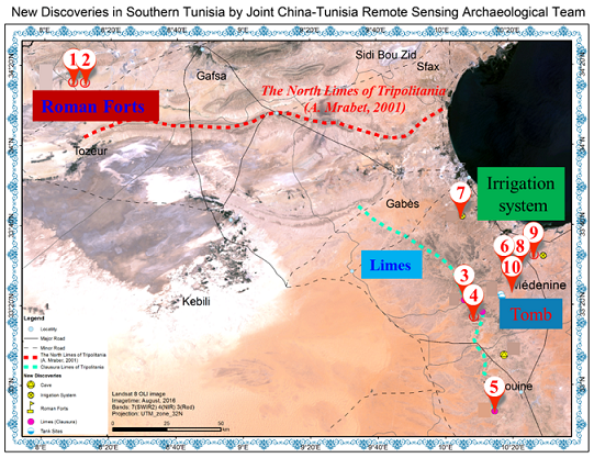
Ten new sites are discovered via remote sensing in southern Tunisia: 1 and 2 are forts; 3, 4, and 5 are limes; 6, 7, and 8 are cisterns; 9 is an irrigation system; 10 is a cemetery.

Success is made after two years of image processing and field investigation. Tunisia is located in the western of the ancient maritime Silk Road, and is an important port for maritime trade in ancient Rome. The new discovery of remote sensing is significant for the study of military defense system in ancient Rome, agricultural irrigation system, the relationship between ancient Rome and nomadic nationality. The discovery reveals the great impression for the direction of the western Silk Road, the transition of the ancient oasis, the change of the environment, etc.

Site of the lime

Forts in ancient Rome
Site of the tank

Site of the irrigation system: the diversion dam is shown in blue and the retaining dam in yellow

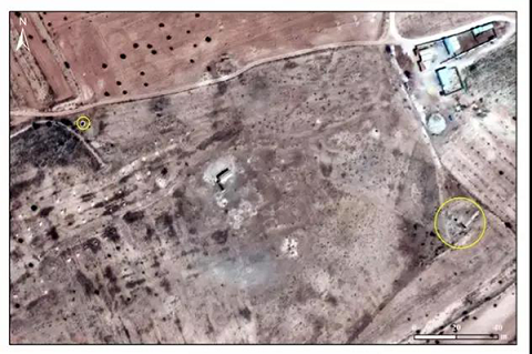
The newly-discovered site of the ancient tomb is indicated by the yellow circle and the known site of forts by the red frame
Specifically, limes and forts are used to defend and protect the border from invasions of nomads from the south and west. The irrigation system and tanks for storage of fresh water are designed for food production to meet the living needs of soldiers and civilians along the border.
The archaeological project mainly utilizes the remote sensing data from high-resolution satellites such as Gaofen-1, Gaofen-2, Gaofen-3, and Sentinel-2, and prejudges the suspected sites on the basis of historical information and ancient maps and by comprehensively utilizing geographic information systems for spatial analysis. In the field verification, the precise location of the site was identified by using the satellite navigation and positioning system, and a joint team of remote sensing experts and archaeologists conducted the field survey and verification.
China leads the world in discovering archaeological sites by means of space technology
In fact, HIST has applied space archaeology technologies to discovering many archaeological remains and conducted extensive cooperation with a lot of countries, reaching the advanced level of the world.
As early as 2013, Wang Xinyuan’s team found five sites of ancient cities, over 10 house remains in two residential villages, one ancient channel site, one ancient road site and one pottery kiln site in the Guazhou (Anxi)-Shazhou (Dunhuang) section of Gansu province along the major route of the Ancient Silk Road. They made a detailed survey of their scale and shape. What the team had discovered fills the archaeological gap of discovering sites of the Han and Tang dynasties in the west of the ancient city Bazhou by using the remote sensing technology and provides abundant physical materials for the study of history and geography of China’s northwest frontier.
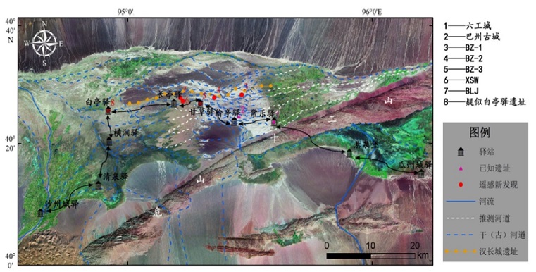
Archaeological discoveries in Guazhou (Anxi)-Shazhou (Dunhuang) section of Gansu province
In 2013, HIST and its hosting institute –Aerospace Information Research Institute (AIR) of the Chinese Academy of Sciences, signed the Memorandum of Understanding with the National Authority for the Protection and Management of Angkor and the Region of Siem Reap (APSARA) to monitor Angkor and its surrounding environment via remote sensing technology, and subsequently to build a “sky-eye” system by using the remote sensing technology, so as to protect Angkor and its surrounding environment in Cambodia.
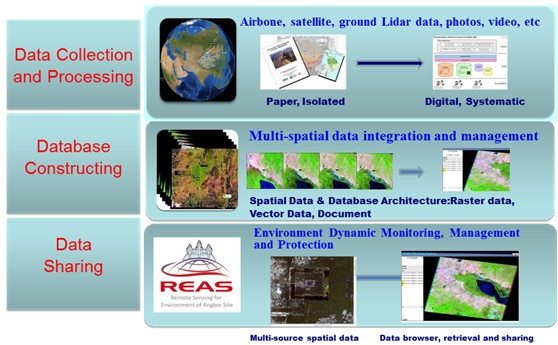
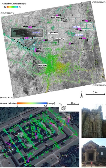
Remote Sensing for Angkor Site
These discoveries of space archeology in Tunisia are of significance in studying the military defense system and irrigation system in ancient Rome, the west-end route of the Silk Road, changes in ancient oases, and environmental evolution.
In addition, Chinese scientists, for the first time, have led relevant countries in Asia, Europe and Africa to discover foreign archaeological remains and conduct systematic research by comprehensively utilizing the remote sensing observation technologies, satellite navigation system and geographic information analysis system, and based on literature analysis, and technologies and methods for space archaeology employed in the field survey. It is of great milestone significance to improve international cooperation and research conducted by the Chinese scientists along the “Belt and Road” to develop a new model of research techniques and methods in space archaeology.

Prof. Guo Huadong, President of DBAR and Director of HIST, unveiled the satellite image of new discoveries with Mr. Mohamed Zin Alabidin, Tunisian Minister of Culture, at the Press Conference.
In his speech at the press conference on remote sensing archaeology along the Belt and Road, Guo Huadong pointed out that one of the DBAR’s core concepts is to carry out research with other countries along the Belt and Road, and China needs to contribute its advanced technologies and ideas to these countries, especially developing countries, which demonstrates this core concept.
Chinese scientists use space technology, satellite navigation system, GIS and other comprehensive techniques, combined with the literature analysis and field research to carry out the space archaeological techniques and methods, for the first time, Chinese scientists have discovered archaeological sites outside China using the remote sensing technology. These sites unveil the layout of the south-line military defense system and irrigation system in ancient Rome.
This is a great symbol and outstanding meanings forming a new paradigm of research technology and method in the discipline of space archaeology. Also a good promote of the research with international cooperation along the “Belt and Road” Initiative.
The DBAR represents an important content of the Big Earth Data Science Project, an A-class pilot research project launched recently by the Chinese Academy of Sciences (CAS). The DBAR is an international scientific programme for Earth observation and big Earth data to aim at the sustainable development of the “Belt and Road” Initiative by sharing data, technologies and knowledge and experience. It will take a targeted approach to conduct in-depth research and scientific cooperation in the development of the big Earth data platform, environmental changes, disaster risk reduction, water resources management, urban development, agriculture and food security, coastal zones and natural and cultural heritage.
The DBAR-Heritage Working Group is committed to using spatial information technology to grasp the authenticity and integrity of the World Heritage sites along the “Belt and Road” and identify challenges posed to their conservation across the globe, so as to formulate well-targeted protection strategies.
Remote Sensing Archaeology is a remote sensing technology developed in the 1960s. It refers to visible, infrared, and microwave electromagnetic waves that reflect, radiate, or scatter from distant objects to detect and identify targets. The visions of human beings are limited, but the emergence of remote sensing technology has given humans a pair of eyes from space to place. With the deepening of research, archaeology has become more and more interdisciplinary, especially in close relationship with many natural sciences. Modern archaeology makes extensive use of satellite photographs, aerial photographs, topographic maps and other professional maps on the Earth's surface to obtain cultural relics information, and to continuously expand the application of new geographic information technology. Remote sensing technology is one of them. Advantage:
1. Remote sensing archeology has many advantages, such as wide coverage, which can obtain the global information of the exploration area;
2. Large spectral range, breakthrough in the visible light range, and availability of information of other wavelengths;
3. Resolution of Time-space-spectral is high, and remote sensing images can be obtained monthly or even daily with sub-meter to centimeter resolution, multi-spectrum, and even hundreds of bands of hyper-spectrum, which enhances the ability to identify features in the detection area;
4. With a certain ability of penetrating, the synthetic aperture imaging radar can penetrate the subsurface, the laser radar can penetrate the forest cover to obtain the ground information, and the ground penetrating radar can obtain the underground buried cultural relics information;
5. Targets can be non-destructively detected, and a lot of manpower, material resources and time can be saved;
Other:
By using remote sensing technology, Chinese scientists have discovered that the tandem system of ancient rivers and lakes covered by dry sand in the Alashan plateau and the ancient Great Wall of China in Sui and Ming Dynasties.To natural heritages, especially the protection of large-scale natural heritages, remote sensing technology has advantages that other technologies cannot match.