Recently, based on the Directional Polarization Camera (DPC) onboard GF-5 satellite, the first global high-resolution (3.3 km) map of fine-mode aerosol optical depth (AODf) over land has been obtained together by the Aerospace Information Research Institute, and the Anhui Institute of Optics and Fine Mechanics, the manufacturer of DPC sensor,and other institutes. This AODf remote sensing observation dataset has the highest spatial resolution in the world. It can reflect the spatial information of major air pollutants (PM2.5, etc.) and provide basic information for atmospheric scientists to "unveil" global haze distribution.
The GF-5 satellite was launched on May 9, 2018, carrying six advanced sensors including the Directional Polarization Camera (DPC). GF-5 is designed as an environmental monitoring flagship among Gaofen satellite series.
DPC is the first space-borne wide field-of-view imager with multi-spectral, multi-angle and multi-polarization measuring capabilities developed by China. The spectral range covers visible to near infrared bands. DPC is able to detect three polarization components at 9 to 12 imaging directions, with swath width about 1850 km. DPC has special channels for detecting aerosol, cloud, water vapor, oxygen and other atmospheric constituents, as well as the monitoring abilities for both land and ocean environment.
Prof. LI Zhengqiang from the Environment Protection Key Laboratory of Satellite Remote Sensing, introduced that AODf data obtained by DPC/GF-5 is the highest-resolution satellite remote sensing product of fine mode aerosol optical depth in the world, about 6 times higher than that of the similar POLDER satellite product of France. Therefore it can reveal the clear details of pollution particles, and provide continuously on-orbit observation of atmospheric fine-mode aerosol over the globe, supporting regional refined pollution control, monitoring of pollution transmission paths in major cities, traceability of particle pollutants and other needs.
Prof. Li said that DPC can provide space observation data for global coverage and rapid monitoring of air pollution. The aerosol parameters obtained by DPC can be used to detect the distribution, source, composition and transmission of fine particulate pollutants in the atmosphere, and the retrieval results are in good agreement with surface monitoring data. From a global perspective, the obtained high AODf regions are consistent with the spatial distribution of typical air pollution areas over the world, and the low AODf levels mainly occur in clean areas.
The synchronized validation data for AODf retrievals from 215 ground-based stations worldwide show that the satellite remote sensing results of DPC have great consistency with ground-based observations. Meanwhile, the joint analysis with surface PM2.5 data in Beijing shows that satellite remote sensing AODf has a good correlation with PM2.5 concentration, indicating the good potential of DPC in quantitative estimation of PM2.5.
However, Prof. Li also pointed out that satellite AODf is the total optical quantity of fine particles of the entire atmosphere, while PM2.5, which is closely related to atmospheirc pollution and human health, refers specifically to the mass concentration of fine particles in the surface layer. "Accurate estimation of surface PM2.5 by satellite AODf still requires a lot of research and innovation work", said Prof. Li.
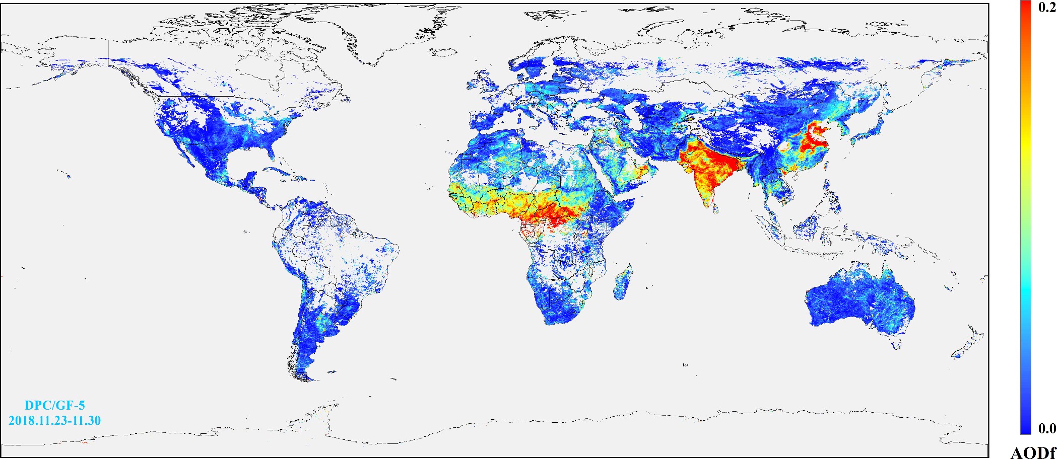
Global-level distribution map of fine mode aerosol optical depth (AODf) over land produced by DPC/GF-5.
Red indicates high AODf regions, while light grey indicates cloud regions or lack of valid data.