Project Name:
Smart management ofcultural heritage sites in Italy and China: Earth Observation and pilot projects
Project Leaders:
Chinese side: Chen Fulong
Italian side: Nicola Masini, from Institute for Archaeological and Architectural Heritage, the National Research Council of Italy (CNR – IBAM)
Team Members:
Chinese side:
Chen Fulong, research fellow with The Aerospace Information Research Institute (AIR) of the Chinese Academy of Sciences (CAS), the International Centre on Space Technologies for Natural and Cultural Heritage (HIST), and professor of the “Hundred Talents Program” of CAS
Wang Cheng, research fellow with The Aerospace Information Research Institute (AIR) of the Chinese Academy of Sciences (CAS), the International Centre on Space Technologies for Natural and Cultural Heritage (HIST), and professor of the “Hundred Talents Program” of CAS
Yang Ruixia, associate research fellow with The Aerospace Information Research Institute (AIR) of the Chinese Academy of Sciences (CAS) and the International Centre on Space Technologies for Natural and Cultural Heritage (HIST)
Zhang Wei, assistant research fellow with The Aerospace Information Research Institute (AIR) of the Chinese Academy of Sciences (CAS) and the International Centre on Space Technologies for Natural and Cultural Heritage (HIST)
Feng Dexian, research fellow with the Zhengzhou Base of International Centre on Space Technologies for Natural and Cultural Heritage
Liu Airong, research fellow with the Zhengzhou Base of International Centre on Space Technologies for Natural and Cultural Heritage Zhengzhou Branch
Italian side:
Nicola Masini, research fellow with Institute for Archaeological and Architectural Heritage, the National Research Council of Italy (CNR – IBAM)
Francesco Gabellone, research fellow with Institute for Archaeological and Architectural Heritage, the National Research Council of Italy (CNR – IBAM)
Rosa Lasaponara, research fellow with Institute of Methodologies for Environmental Analysis, the National Research Council of Italy (CNR-IMAA).
Project hosted by:
Chinese side: Aerospace Information Research Institute (AIR) of the Chinese Academy of Sciences (CAS) and the UNESCO International Centre on Space Technologies for Natural and Cultural Heritage (HIST)
Italian side: Institute for Archaeological and Architectural Heritage, the National Research Council of Italy (CNR – IBAM)
Project Period: 2013 — 2015
Project Overview:
Research contents and objectives: Through enhancement of cognition, innovation of methods and development of technology, the Sino-Italian cooperation project carries out research on the application of intelligent heritage management to support continuous monitoring and integrity protection of cultural heritage sites. The project focuses on mutual exchanges and training in remote sensing, geophysics and diagnostic tools in cultural heritage research, for the purpose of promoting complementary advantages and achieving common progress. Typical cases include: 1) Ancient Rome, Italy; 2) Hongcun (World Heritage Site), Anhui, China; 3) Silk Road.
Cooperation forms:
Joint research by Chinese and Italian sides on cultural heritage conservation and relevant technology and methods, with a focus on continuous monitoring and scientific management of world heritage sites;
To witness and probe the ancient culture of classic heritage sites in China and Italy;
Academic exchanges between research personnel of the National Research Council of Italy and the Chinese Academy of Sciences to promote complementary technological advantages.
Sharing and use of remote sensing data of the two sides.
Project Outcomes:
Outcomes of the project in different phases are as follows:
The proposal for establishing a joint virtual laboratory was adopted to share data and achievements
In November 2012, a Sino-Italian seminar focusing on remote sensing and cultural heritage was held in Beijing
In April 2013, Chinese and Italian scientists held informal meetings in Beijing
In August 2013, the mid-term project report was submitted
In August and September 2013, preliminary results of this project were exhibited on the European Space Expo entitled “Sensing the Past, COSMO SkyMed and Radar technologies for Archaeology”
In October 2013, Chinese and Italian research teams conducted a joint field campaign in Luoyang, Kaifeng and other ancient cities known as the original section of the Silk Road and held bilateral academic seminars in Zhengzhou as well.
In December 2013, the Chinese research team visited the National Research Council of Italy; the two sides held a bilateral academic seminar in Rome and conducted joint investigations in the ancient city of Rome and Pompei.
For the further implementation of this project, two sides have reached consensus on joint archaeological researches by remote sensing, scholar exchanges, the establishment of a virtual laboratory and etc. In-depth studies have been conducted in typical heritage sites of China and Italy. Major joint research outcomes can be summarized as follows:
A surface deformation rate map of the ancient Luoyang city was derived using COSMO SkyMed small baseline SAR interferometry, initially implying the impact of human activities on this site (Fig. 1);

Fig. 1
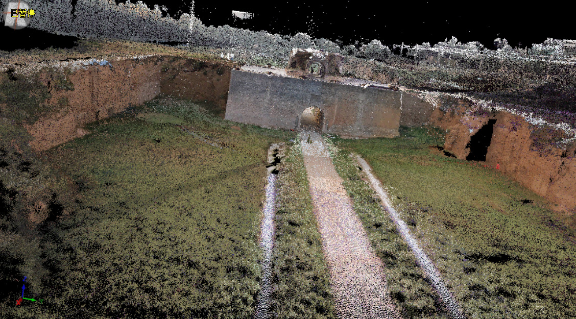
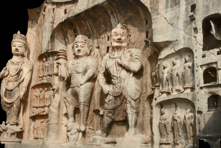
Chinese and Italian research teams conducted joint investigations in Luoyang, Kaifeng and other ancient cities distributed along the original section of Silk Road (Fig. 2), obtained the three-dimensional landscape of Hanguguan in Eastern-Han Dynasty (Fig. 3) using ground-based laser scanning, and acquired a three-dimensional model of a Buddha statue from Longmen Grottoes (Fig. 4) by close-range photos.;
Fig. 2
Fig. 3
Fig. 4
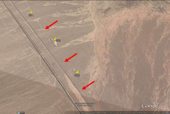
The researchers detected and identified ancient ruins and roads in the Xinjiang segment of the Silk Road by median- and high-resolution optical images (Fig. 5: red arrows mark ancient roads and yellow pushpins indicate potential archaeological sites);
Fig. 5
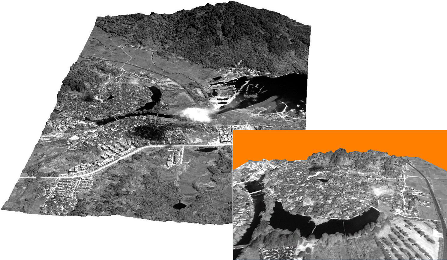
Researchers acquired a three-dimensional scenario covering the Hongcun ancient village and its surroundings (Fig. 6) through the use of PLEIADES stereo-pair satellite images calibrated by GPS ground control points.
Fig. 6